Learn about Geoserver Monitoring
Spatineo Monitor is a cutting-edge SaaS-based solution that evaluates the continuous Quality of Service (QoS) of geospatial web services. It’s your go-to tool for analyzing spatial web services, including WMS, WFS, and WMTS. Here’s why Spatineo Monitor is essential for spatial data providers.
Spatineo Monitor automates the measuring of spatial web services, providing insights and validation against industry standards. Our reporting and sharing functions enable clear visibility, optimizing your spatial data infrastructure.
What is Geoserver monitoring?
Geoserver monitoring refers to the continuous observation and analysis of a Geoserver’s performance, availability, and functionality. Geoserver is an open-source server designed to facilitate the sharing, processing, and editing of geospatial data. Monitoring involves gathering data on various aspects of the server, such as response times, resource usage, and error rates, to ensure that it’s running efficiently and effectively.

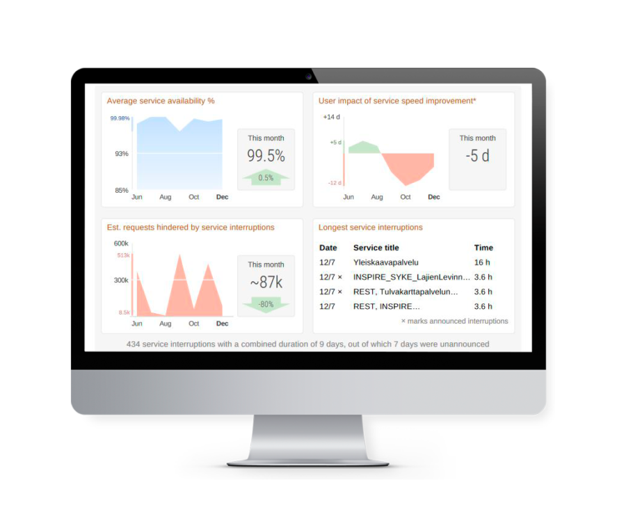
- Observe when, where and how your spatial web services are used.
- View which layers get the highest number of hits.
- Learn which resources you need to enhance the robustness of your service.
- Get valuable information on the capacity and availability of your service.
- Optimise your investments in Spatial Data Infrastructure.
- Forecast trends affecting your service environment.
- Use comprehensive automated reporting for error alerts and to perform stress tests.
Why is Geoserver monitoring important?
Geoserver monitoring is essential for several reasons:
- Performance Optimization: By continuously observing the server’s performance, administrators can detect and rectify issues early, preventing slowdowns and outages.
- Resource Management: Understanding how resources are being used allows for better planning and allocation, ensuring the server operates efficiently.
- Security: Monitoring helps in identifying unusual activities, which could be indicative of a security breach.
- Compliance: For organizations that need to adhere to specific regulations, monitoring helps in maintaining and proving compliance.
Start Free 7-day Trial
Spatineo Monitor is an invaluable tool for developing your spatial web services and getting the whole value out of them. We offer a free 7-day trial with full features to get to know the product and its benefits.

Benefits of Geoserver monitoring?
he benefits of Geoserver monitoring include:
- Increased Reliability: By proactively detecting and resolving issues, the server’s overall reliability is enhanced.
- Improved Performance: Regular monitoring helps in optimizing the server’s configuration, leading to faster response times and higher user satisfaction.
- Cost Savings: Through efficient resource utilization and timely problem resolution, organizations can save on unnecessary expenses.
- Enhanced Security: Continuous monitoring contributes to a more secure environment by identifying potential vulnerabilities and breaches.
What will you get with monitoring?
With Geoserver monitoring, you will gain:
- Real-time Insights: Immediate access to vital statistics and metrics.
- Trend Analysis: Ability to analyze trends over time, aiding in capacity planning and performance tuning.
- Alerting: Custom alerts for specific events or thresholds, allowing for quick response.
- Reporting: Detailed reports for analysis, compliance, and decision-making.
- Peace of Mind: Knowing that the system is under constant observation and control.
Compatibility with Industry Standards
Spatineo Monitor is compatible with most-used industry standards, such as WMS, WMTS, WFS, ESRI MapServer REST and INSPIRE ATOM.

How to get started with Geoserver monitoring?
Getting started with Geoserver monitoring involves several key steps:
- Identify Objectives: Determine what you need to monitor, such as performance, security, or compliance.
- Select Tools: Choose appropriate monitoring tools that suit your needs. Spatineo provides one of the industry leading products.
- Configure Monitoring and get started: Set up the monitoring parameters, thresholds, and alerts according to your specific requirements. Our team will help you in the configuration and setup.
As you get more data from your services you can enhance the security and performance of the system.
- Implement Security Measures: Ensure that the monitoring activities themselves are secure and compliant with relevant regulations.
- Review and Analyze Regularly: Regularly review the collected data, generate reports, and make necessary adjustments to keep the system optimized.
“Besides being easy to use, Spatineo Monitor has proved to be powerful. We get a comprehensive view of all the spatial web services we are providing, and if problems arise we can allocate our resources to the maximum in fixing them.”
– Henri Jutila, Senior Adviser, Geographic Information, Helsinki-Uusimaa Regional Council
Start monitoring your success with our tried and tested product. Request your 7-day free trial with the form below or contact us directly!
"*" indicates required fields
Contact Us for More Information!