Take Control of Your Impact
When you want to know the real effects of your spatial data, Spatineo Impact is the right tool for you. It is designed to measure and analyse your data flows to better reach your strategic goals.
Know the Concrete Impact of Your Spatial Data
Spatineo Impact is a strategy-level tool for analysing the real effect your spatial data has on your customers and our whole society. More than just a service-as-a-product, Spatineo Impact has its own methodology for setting concrete meters for your organisation. The meters guide you in reaching your strategic goals regarding spatial data. The product also makes it visually easy to monitor the goals based on their indicators.

Who Is Spatineo Impact For?
- Organisations that produce and publish spatial data.
- Public sector operators, private companies, and citizens that use spatial data.
- Organisations that develop spatial services and apps for citizens, and citizens using these apps.
- Organisations responsible for Spatial Data Infrastructures (SDIs).
What Do You Get from Spatineo Impact?
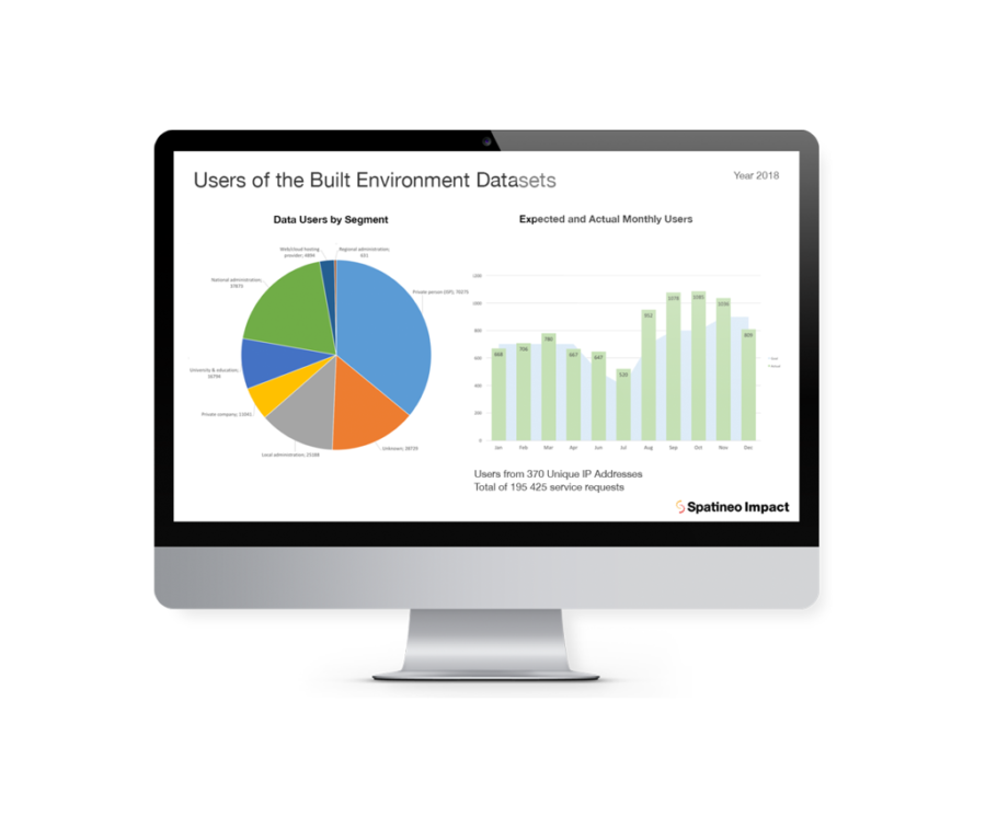
- Visible presentations of the effect of your spatial data.
- Systematically measured and analysed information on the relevance of datasets to users.
- Dataset-specific information on high-value assets relating to strategic goals.
- Constant development in recognising both successes and areas of improvement.
- Better, measurable strategic goals in the future with improved internal operations and processes.
- Justification for decision making regarding where to invest in developing spatial data offerings, content, updating, APIs, and communication.
How Do You Measure the Societal Impact of Spatial Data?
Spatial data plays a more important role in our society than is usually thought. Spatineo Impact is also designed to enhance the use of that data for common benefit. The effects of spatial data can be direct or indirect, depending on the role of an user in the value network. The effects can often be seen only in the long run when the impact of spatial data combines with other factors.
Spatial data touches for example:
- common wellbeing
- systems and societal developments
- issues on both local, county, state, societal, and political levels
- business innovations
- planning smart cities
- analysing carbon neutrality
- streamlining operations.
Here’s How Spatineo Impact Works
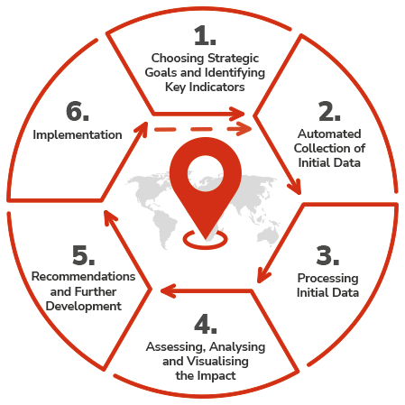
1. Choosing Strategic Goals and Identifying Key Indicators
- Clear and unambiguous indicators that can be measured and monitored.
- Strategic goals and key indicators are set in cooperation with the client, often in an iterative manner.
- The better the data and clearer the goals and indicators, the better it works.
2. Automated Collection of Initial Data
- The aim is always to automate the collection of initial data.
- The data is sourced, for example, from web sites, online maps and Spatineo SaaS services and complemented by interviews and online queries.
- Combining initial data from various sources is one of the key features of Spatineo Impact.
3. Processing Initial Data
- The assessment on the use of the spatial data in the organisation is carried out using trend indicators and measuring the success of possible previous goals.
4. Assessing, Analysing and Visualising the Impact
- Successes are made visible by providing visual presentations of the data and showing the impact of individual work input.
- Painting a shared situational picture – what is the relation of the current situation to the goals – and asking if the client is on the right track according to the indicators?
- Constantly developing and updating dashboards provide a situational picture.
- Reports are based on different organisational needs and levels, and analysis is sorted by services, user groups, and data groups.
- Reports and analyses can be configured for both commercial and public sector needs.
5. Recommendations and Further Development
- Bringing a data-based rationale behind strategic work and aiming for a comprehensive knowledge transfer to the client.
- Assessment results help in setting further measurable goals for enhancing operations and cost-effectiveness.
- The process creates novel connections in the organisation and encourages cooperation for an even stronger impact.
- Providing not only concrete goals but also options to be evaluated, technological recommendations, and tips to improve communications.
6. Implementation
- The results of can be implemented by tangible changes and upgrades in various operations concerning spatial data.
- The client can perform the changes and upgrades independently, in cooperation with Spatineo, or outsource them wholly to us.


