.jpg?width=50&name=Spatineo%20-%20JooWorks%20-%20Henkil%C3%B6kuvat0023%20(1).jpg)
ISPRA, through the SINA (National Environmental Information System), is one of the largest providers of spatial web services in Europe. Their services cover data from environmental datasets to urban and educational information. Delivering all of these spatial web services to their end-users requires great care, and now ISPRA has taken the step to make that process more efficient and transparent with Spatineo Monitor.
Quality of Spatial Web Services
Many of ISPRA’s spatial web services have to be available to users without any bottlenecks. Availability and compatibility are the main aspects ISPRA has to take into account when maintaining their spatial web services, as they have to follow policy guidance set by the Italian Ministry of Ecological Transition (MiTE previously Ministry for the Environment and the Protection of Land and Sea). The data has to be INSPIRE compliant, and ISPRA has set that as one of their main goals; fulfil INSPIRE requirements and possibly take one step further with their data quality.
Maintaining the quality of their spatial web services boils down to ensuring that the data is delivered with precision to the end-users. This is where Spatineo Monitor comes in.
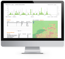
ISPRA started using Spatineo Monitor in summer 2021. They adopted the usage of constant monitoring, executive automated reporting and alerts to their spatial web services.
Better Decision Making Based on Data
Usage of Spatineo Monitor streamlines many processes that were done manually before. For example, checking compliance of INSPIRE spatial web services to our industry’s standards is now a one-click process. Creating and scheduling extensive reports on the wellbeing, usage and availability of the spatial web services is now also something ISPRA can do in just a few minutes.
All of these new automations free up workload from SINA’s GIS personnel and give them more insights on how to improve their services and infrastructure in the long run. As data is being dug up from the silos all over Europe, ISPRA has now the necessary tools to be the frontrunner in that mission.
National Environmental Information System is getting ready to serve their spatial web service users better than ever, we here at Spatineo are proud to be part of this mission. One of our goals is to make European Spatial Data more accessible to everyone, and we see that ISPRA & SINA is definitely on the right track!

.png?height=200&name=Kopio%20Blog%20Featured%20image%20(1).png)